Exercise 2: A WCS exercise built with usno_identify.
Here I use usno_identify to build the test file. Here I create the type
of file I refer to as a *.xyrd file. It contains the same info as the
wcs_setup.out file, but the data for each source are on a single line.
I want to use my n4625 acam stack and create a *.xyrd file to use in testing wcs_markII.
I do this when the internet is down, so I use my stored dss image of n4625:
% ls $critfils/tdat
ds9_n4625.png  dss_n4625.fits  hetacm_n4625.fits  README.Test_n4625  wcs1/

  % cp $critfils/tdat/hetacm_n4625.fits .
  % cp $critfils/tdat/dss_n4625.fits dss.fits

Next, because I know this image has an old, very wrong, tcs header, I remove all wcs info
from the header of this image:
  % remove_wcs hetacm_n4625.fits
After doing this you should view the image with ds9 and confirm that only X,Y value
are displayed. No Ra,Dec values appear because the WCS information, if present, was
removed from the header.

Then I run some quicky tests:
  % wcs_present_in_header hetacm_n4625.fits
  N

My wcs info is gone, so I'll need some basic info for when I run usno_identify. I need
RA,DEC and a field size. I use rc3gal to get the position for n4625, and I know a good
field size for the acm is 4.0 arcminutes.
Results of the RC3 search:
Name_RC3      RA_2000DEC_2000    Type     Input_name
NGC  4625    12:41:53.00 +41:16:27.0  .SXT9P.   n4625
dssget 190.470825  41.274166 10.0 dss poss1_red

So I'll be entering:
  12:41:53.00  +41:16:27.0  4.0

To run:
   % usno_identify hetacm_n4625.fits 20.0 blue 16

* Because there is no WCS header info I must manually enter info about
  where the image is on the skay and the size of the image. I use:
  RAsex_,DECsex, Rad_ArcMin = 12:41:53.00 +41:16:27.0 4.0

NOTE: Originally I used my stored dss image, but this turned out to be just
      a little to small for my acm stacked image. So, I ran this exercise when the
      internet wa available and I pulled a large dss field.

      I had to flip the image orientation (I flipped the Y axis) to get an
      alignment that allowed me to match stars.

*** I made the file:  usno_identify.final_list
% cat usno_identify.final_list
 565.16 497.97   12:41:43.3608 +41:15:47.3099   10
 433.35 455.45   12:41:46.4316 +41:16:00.3287   13
 665.79 410.09   12:41:40.7364 +41:16:05.7806   8
 704.05 255.61   12:41:39.4332 +41:16:48.5037   7
 204.89 119.84   12:41:51.0648 +41:17:37.1182   18
 640.43 740.80   12:41:42.1620 +41:14:36.9974   9
 333.69 73.92   12:41:47.7852 +41:17:46.0446   15

--------------------------------------------------------------------
NOTE: For an *.xyrd file:
% make_xyrdfile hetacm_n4625.fits usno_identify.final_list
*** May embed this into usno_identify
Format I need:
     241.040     1115.340   346.367767334   12.421183586     194  23:05:28.26 +12:25:16.3
     703.170      258.290   190.414305000   41.280139917       1  12:41:39.4332 +41:16:48.5037

This makes the file = hetacm_n4625.xyrd

% make_xyrdfile hetacm_n4625.fits usno_identify.final_list
% cat hetacm_n4625.xyrd
# Sources collected with make_xyrdfile
# data
     565.160      497.970   190.430670000   41.263141638      10  12:41:43.3608 +41:15:47.3099
     433.350      455.450   190.443465000   41.266757972      13  12:41:46.4316 +41:16:00.3287
     665.790      410.090   190.419735000   41.268272389       8  12:41:40.7364 +41:16:05.7806
     704.050      255.610   190.414305000   41.280139917       7  12:41:39.4332 +41:16:48.5037
     204.890      119.840   190.462770000   41.293643944      18  12:41:51.0648 +41:17:37.1182
     640.430      740.800   190.425675000   41.243610388       9  12:41:42.1620 +41:14:36.9974
     333.690       73.920   190.449105000   41.296123500      15  12:41:47.7852 +41:17:46.0446

At this stage I can make the wcs_setup.out file (like in example 1):
% cutup_xyrdnames hetacm_n4625.fits
Coordinate data file = hetacm_n4625.xyrd
% cat wcs_setup.out
10
565.160 497.970 190.430670000 41.263141638
13
433.350 455.450 190.443465000 41.266757972
8
665.790 410.090 190.419735000 41.268272389
7
704.050 255.610 190.414305000 41.280139917
18
204.890 119.840 190.462770000 41.293643944
9
640.430 740.800 190.425675000 41.243610388
15
333.690 73.920 190.449105000 41.296123500
--------------------------------------------------------------------
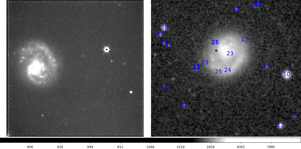
Below I show two finding chart from the above exercise.
 |
|
My initial usno_identify view of my NGC4625 acm image (left) and the
corresponding DSS view (right).
|
 |
|
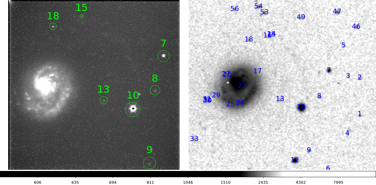
My usno_identify view of my NGC4625 acm image (left) and the
corresponding DSS view (right). I have pulled a larger field DSS
image than the example above. The DSS identification labels changed because I
pulleds stars to a deeper magnitude limit.
|
First, since I have a good number of fit points, I run my well=tests
linear solution (wcs_2lin).
 |
Here is the result from my test wit wcs_2lin:
My wcs_setup.out file is present, so I run wcs_2lin:
% wcs_2lin hetacm_n4625.fits Y
My fit residuals in the final image displayed as:

Decision time, the final position residuals (in arcesconcds) are:
   0.287    0.949      7    (RES_arcsec,Nstars)
|
The full wcs_trs treatment of the same data above did not work to completion.
I was creating a WCS that did not properly account for the image flip. The firast place to
start was to look at the trs_ solution first. Here is an example of how I convinced
myself that this part of the code was performing properly.
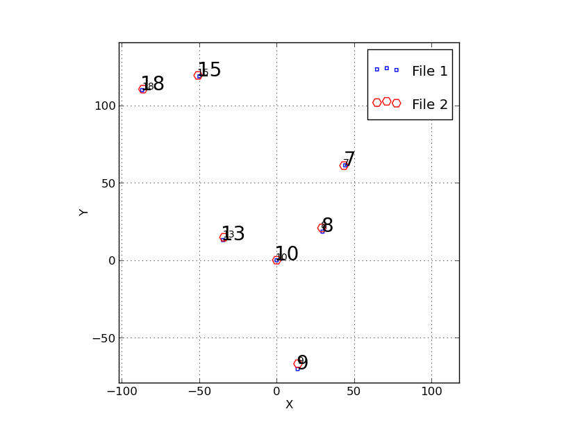 |
To diagnose a problem I was having with image produced initially by
wcs_trs I used my trs_ plotting package named trs_2plot. The code that
performs the fit is called trs_solve_2, and it produced a bunch of *.xy
files. These are explained in the file "Explain_Files.trs_solve_2". I
made a number of plots that showed me that, as far as trs_ was concerned, the
coordinate flip, scaling and rotation were being performed correctly. I made the
plot above that shows the original coordinates of the RA,DEC projected onto the
tangent plane in units of arcseconds (the small blur squares). The large red circles
are my image coordiantes in pixel units after conversion to the sky system using a
parity flip, a translation, a scale, and a rotation. Here is how I masde the plot:
% trs_2plot file1_trans.xy file2_rotate.xy
I made this in a subdirectory, so I had to rmember to copy the
PointNames file to there as well as the *.xy files.
The points line up quite well, which accounts for why my rms residuals
looked fine in the fit when I ran wcs_trs. Hence, it would seem that my
problem(s) are downstram: my routines that build and install the new
header are not working somewhere. By the way, I review in a laborous and
verbose way how to use trs_ plotting routines in my Big_Codes section
that discusses the whole trs_ methodology:
file:///home/sco/sco/scohtm/scocodes/trs_/trs_plotting.html#SEC_2
I don't link to the URL directly here since this doc will almost
certainly be moved around soon. But you get the idea.
|
Back to SCO CODES page