Parallactic Angle
What is parallactic angle? This subject comes up continually in HET
discussions. We need a concise description! Actually, the
spherical trig equations are not that difficult, but it is important
to clarify the angle conventions used upstream in the calculations.
In this little webdoc I'll try to make this clear to my satisfaction.
- A basic description and equations.
- The working equations for HET.
- A simple approach: bonehead all the way!
- How to compute parallactic angle (Q).
- What HET does (not really q!).
A basic description and equations.
You can read
a good description of the parallactic angle here . I took the very nice
figure shown below from that page:
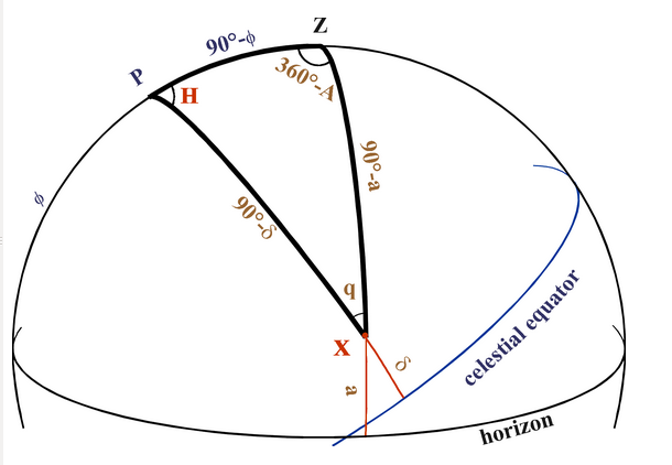 |
To convert between the horizontal and equatorial coordinates for an object X,
we use a spherical triangle often called "The" Astronomical Triangle: XPZ,
where Z is the zenith (top of the sky), P is the North Celestial Pole,
and X is the object we are pointing at on the celestial sphere.
Recall that a great circle (GC) on the celestial sphere
(CS) has a circumference that is the maximum circumference for the
idealized sphere. So, the equator IS a GC, but a circle of constant
declination (except on the equator!) IS NOT a GC. I am not
going to the trouble of making greek letter here, so I refer to
the latitude (denoted with a greek phi) as phi, and I refer to
the declination (denoted with a greek delta) as DEC.
   a   = altitude (angle directly above the horizon)
   phi = observer's latitude
   DEC = Declination of the target object.

The sides of the triangle:
   PZ is the observer's co-latitude = 90deg - phi.
   ZX is the zenith distance of X = 90deg - a.
   PX is the North Polar Distance of X = 90deg - DEC.

The angles of the triangle:
   The angle at P is H, the local Hour Angle of X.
   The angle at Z is 360deg-A, where A is the azimuth of X.
   The angle at X is q, the parallactic angle.
|
For my tastes, the easiest way to explain the parallactic angle, q, is
to imagine two great circles (GC) on the sky:
- The GC that contains the TARGET (X) and the ZENITH (Z).
- The GC that contains the TARGET (X) and the POLE (P).
The angle between the plane containing these two GC is the
parallactic angle (q in our diagram above)! Two other important
angles in our diagram above, especially in the context of an
alt-az telescope like the HET, are the altitude (a) and azimuth
(A).
The working equations for HET.
As far as I can tell, the basic equations for pointing the HET are
described in Frank Ray's 1994 "HET Technical Report #42". All HET
TCS (Telescope Control System) seem to have their genesis there.
This is an important paper, and I should have a link to it. Unfortunately,
the PDF for this work is very large, and I do not carry it around in
my SCO personal notes for that reason. There should be a WEB LINK
for getting this report!!!
I did receive some formulae that may be helpful
at some stage, but there may be some misunderstanding of angle
conventions that remain (i.e. what angles are 0-360, and which
use a 0-180 convention with an associated sign?). The important
reasons for including these code snippets is that somewhere here
are the equations that the HET TCS uses (or used) to compute
parallactic angle.
 From Matt (02/20/2015)
===========================================================================
So it should be a constant offset between the parallactic angle and the
position angle not a constant offset between the Az and position angle.

There is some web code that computes this:
/home/het/astronomer/HETweb_Programs/Instruments

rho.c:
#define R2D 57.29577958      /* degrees per radian */
#define Q 0.417863           /* sin alt * sin latitude */       Not alt!
#define P 0.493336           /* cos alt * cos latitude */       Not alt!
#define telangle          55.0
#define latitude          30.6716667


The explanations of Q,P above are INCORRECT
They should read:

#define Q 0.417863           /* sin telangle * sin latitude */
                                 0.81915     *     0.51012         =  0.417864

#define P 0.493336           /* cos telangle * cos latitude */
                                 0.57358     *     0.860105        =  0.493339

DEC2 = DEC2/R2D;
az = 1/P*(sin(DEC2)-Q);
tde = P*cos(az/R2D) + Q ;
tde = atan2(tde,sqrt(1-tde*tde)) * R2D;
h = (cos(telangle/R2D)*sin(az/R2D))/-cos(tde/R2D);
h = atan2(h,sqrt(1-h*h))*R2D;
   parang=cos(h/R2D)*cos(az/R2D)+sin(h/R2D)*sin(az/R2D)*sin(latitude/R2D);
parang = atan2(sqrt(1-parang*parang),parang)*R2D;

Then if you are working in the West you have to do a 360-parang
===========================================================================


 From Jim  (02/04/2015)
===========================================================================
Steve,
Here is how the Tcs calculates paralactic angle.  Telecentric azimuth
is the structure azimuth and telecentric elevation is basically
55 degrees.  Our latitude is 30:40:53.17

  Intermediate variables.
     P = cos( Telecentric Elevation ) * cos( Latitude )
     Q = sin( Telecentric Elevation ) * sin( Latitude )

These parameters are dependent only on the Az/El of the telecentric axis.

     Tde: Telecentric Declination
      H0: Telecentric Hour Angle

     Tde = asin( P * cos( Telecentric Azimuth ) + Q )

     H0  = asin(-cos( Telecentric Elevation ) * sin( Telecentric Azimuth ) / cos( Tde ) )


      Pa Paralactic Angle = acos( cos( H0 ) * cos( Telecentric Azimuth )
           + sin( H0 ) * sin( Telecentric Azimuth ) * sin( Latitude ) )

Best wishes,
Jim
===========================================================================
A simple approach: bonehead all the way!
Viewing the nice figure above, it becomes clear that the parallactic
angle (q in our figure) really depends on three quantities: the hour angle
of the target, the Declination of the target, and the Latitude that
your are observing from. The code snippets above are nice, but certain
angle conventions are not clear (to me) and much of the code is
built for the HET. In surfing around, I found references to how
this is done in python with astropy. Again a lot of the angle
conventions (units, signs, ranges, ...) are buried in the calls
to the astropy routines, and trying to follow the extremely
poor astropy coordinates/units documentation does not get us
very far. However, the python code below does, in fact, reveal the
equations you need (in the comments!) to compute q given
(HA,Dec,Lat). I'll code this up (in an OTW environment) so that
I understand the numerics (units, signs, precision) and produce
a simple command line tool that does the calculation.
the URL where I read about this:
https://github.com/brandon-rhodes/pyephem/issues/24

The not-so-clear Python code (using astropy):
from math import sin, cos, tan, atan
import astropy.units as u
import ephem

##-------------------------------------------------------------------------
## Parallactic Angle
##-------------------------------------------------------------------------
def ParallacticAngle(HA, dec, lat):
    '''
    Function to calcualte the parallactic angle.

    Equations from:
    "A treatise on spherical astronomy" By Sir Robert Stawell Ball
    (p. 91, as viewed on Google Books)


    sin(eta)*sin(z) = cos(lat)*sin(HA)
    cos(eta)*sin(z) = sin(lat)*cos(dec) - cos(lat)*sin(dec)*cos(HA)


    Where eta is the parallactic angle, z is the zenith angle, lat is the
    observer's latitude, dec is the declination, and HA is the hour angle.

    thus:

    tan(eta) = cos(lat)*sin(HA) / (sin(lat)*cos(dec)-cos(lat)*sin(dec)*cos(HA))
    '''
    assert type(HA) == u.quantity.Quantity
    assert type(dec) == u.quantity.Quantity
    assert type(lat) == u.quantity.Quantity
    HArad = HA.to(u.radian).value
    latrad = lat.to(u.radian).value
    decrad = dec.to(u.radian).value
    taneta = cos(latrad)*sin(HArad) / (sin(latrad)*cos(decrad) - cos(latrad)*sin(decrad)*cos(HArad))
    return atan(taneta)*u.radian
Hence, the whole calculation comes down to the two equations
in red! Taking the ratio of these two equations, and finding the
angle whose tangent has this value gives us our parallactic angle, q.
The bonehead aspect of this is how I will now go about confirming
that my (eventual) calculation of parallactic angle is correct. To
do this, I collect FITS header information from LRS images stored
on mcs. I used the gethead routine in a script to run something like:
gethead blah.fits DATE-OBS UT ST RA DEC AZIMUTH HA ZD PARANGLE >> HET.LRS_INFO
I process the HET.LRS_INFO result for 38 LRS images with a small piece
of python code (located in the subdirectory that holds this very webdoc):
$scohtm/het+virus/het_upgrade/parallactic_angle/work_stuff/info.py
Basically info.py does a few simple calculations, but in the end I
used it to produce single files, each containing a column
in the original big file (called HET.LRS_INFO):
% wc -l list.*
  38 list.AZIMUTH
  38 list.DATE-OBS
  38 list.DEC
  38 list.HA
  38 list.PARANGLE
  38 list.RA
  38 list.ST
  38 list.UT
  38 list.ZD
How to compute parallactic angle (Q).
From the exercise above I had a TCS-produced set of values
relating sky coordinates and time. My goal for the purposes
of processing CAT data is to compute the parallactic angle, Q,
for any CAT image. As the CAT image headers contain only the
UT data and time that they were taken (the isot-format date
string in the astropy Time module terminology), I also needed
some tools that allowed me to compute things like sidereal time (ST)
and hour angle (HA). I had to construct a table of sky coordinates
(RA,DEC) for the CAT image positions. This table of RA,DEC
positions was collected from my README notes in the CAT data
subdirectories. Using the LRS data described above, I was
able to confirm my parallactic angle calculations, and results
from my 38 LRS test cases are shown below:
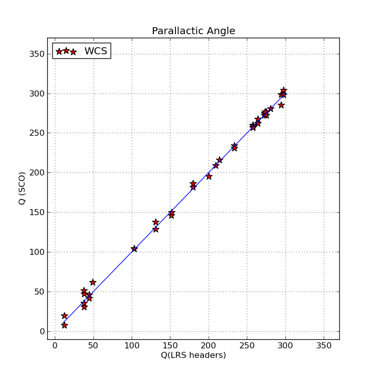 |
|
Parallactic angle (Q) values computed with the script Cal_q.sh (which uses the
bash shell script mcd_parallactic_angle) are plotted on the Y axis. The
corresponding parallactic angle values from the LRS images headers (contained
in the file list.PARANGLE) are plotted on the X axis. The blue line has a slope
of unity. The small amount of scatter is the result of the LRS value being
referred to the center of the HET track (as I believe this is the angle that
the rotator maintains during an HET observation).
|
The details of how these calculations were performed are described in the document
Tasks for Coordinates, Angles and Time.
What HET does (not really q!).
The HET really uses a "Parallactic Direction", and the real
parallactic angle. Also, the value is always computed for
the center of the HET track. Read the terrible details
Read the terrible details here.
Back to HET Pointing Tests if Feb19,2015