image_pa
- Early examples
- Online help info added in Aug2017
Derive the position angle of image (in degrees CCW from +Y) that has a valid WCS installed.
% image_pa n3379_B.fits
Early examples
There is a rather elaborate test script that retrieves and
interesting DSS image and runs image_pa. It also displays the
image in a ds9 window and draws the Ra,Dec grid according to
the WCS in the image header. I show this script here:
% got
% cd T_runs/image_pa/ex0/S
% cat GRAB_and_RUN


#!/bin/bash
# Pull over a DSS image that has NORTH that is
# not quite straight up.
cp $tdata/T_images/S2_dss/dss_bsc5-0747.fits .

printf "\n\nI am running image_pa on the DSS image named dss_bsc5-0747.fits\n"
printf "Run with verbose mode On/Off:"
read vmode

if [ $vmode = "On" ]
then
 date >Verbose.On
else
 printf "\tI am not running in Verbose mode! \n"
fi

#
image_pa dss_bsc5-0747.fits

fitsin="dss_bsc5-0747.fits"

# display image
ds9_open 800 800
xpaset -p ds9 frame frameno 1
xpaset -p ds9 file $fitsin
# impose the grey-scale limits (z1,z2)
z1="0"
z2="10000"
xpaset -p ds9 scale limits $z1 $z2
# zoom to fit the entire image
xpaset -p ds9 zoom to fit

cat NE.reg | xpaset ds9 regions -format ds9

cat xycirc.reg | xpaset ds9 regions -format ds9
printf "\n\nI used "xycirc.reg" to show the circle of points used. \n"

# draw in the coordinate grid
xpaset -p ds9 grid yes
I wrote this script when I was developing some VIRUS astrometry
code. In Sep2015 we had mad some observations of the bright star BSC5-0747
at AZ=0. This star was far in the north, and as fate would have it, happenned
to be located on a POSS-II plate where the digitized scan did NOT
have North in a perfect straight up direction (i.e. the digital images
was not NUEL = North UP East LEFT in orientation). My code had assumend this
would always be the case. The figure below was mad with the ex0
test example shown above.
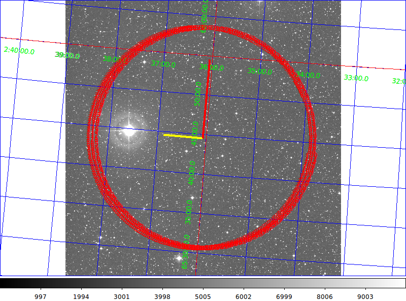 |
The figure generated with test case 0 (ex0) for the
image_pa script. I used the ds9 analysis option to
plot the Ra,Dec grid for the image (the blue lines above).
The result of image_pa is the direction to North (thick
red line) and the direction East (thick yellow line). We
see that this legend agrres well with that generated by
ds9 using the WCS in the DSS image header. Just because this is
a rather rare case, here is the part of the header that
identifies this Schmidt plate:
ORIGIN  = 'STScI/MAST'         /GSSS: STScI Digitized Sky Survey
SURVEY  = 'POSSII-F'           /GSSS: Sky Survey
REGION  = 'XP081   '           /GSSS: Region Name
PLATEID = 'A1MB    '           /GSSS: Plate ID
SCANNUM = '01      '           /GSSS: Scan Number
DSCNDNUM= '00      '           /GSSS: Descendant Number
TELESCID=                    3 /GSSS: Telescope ID
BANDPASS=                   35 /GSSS: Bandpass Code
COPYRGHT= 'Caltech/Palomar'    /GSSS: Copyright Holder
SITELAT =               33.356 /Observatory: Latitude
SITELONG=              116.863 /Observatory: Longitude
TELESCOP= 'Oschin Schmidt - D' /Observatory: Telescope
INSTRUME= 'Photographic Plate' /Detector: Photographic Plate
EMULSION= 'IIIaF   '           /Detector: Emulsion
FILTER  = 'RG610   '           /Detector: Filter
PLTSCALE=                67.20 /Detector: Plate Scale arcsec per mm
|
Just to be complete here is the run line and output actaully
used for the DSS image (named "dss_bsc5-0747.fits"):
% image_pa dss_bsc5-0747.fits
355.0000   85.0001
The values that image_pa sends to standard out are the
position angles of North and East respectively, as well as the
small offset angle from North. Also present
will be a hardcopy version and an explanatory file:
% cat image_pa.out
 355.4000   85.4000   -4.6000

% cat image_pa.explain
paN paE (f9.4)
paN = angle in degrees CCW from +Y of North direction
paE = angle in degrees CCW from +Y of East direction
dPA = small angle relative to +Y (+ is CCW, - is CW)
Online help info added in Aug2017
In Aug2017 I decided to add the ability to write a second form of WCS
header to my images. In the process of this I upgraded image_pa and added
some improved online documenation.
% image_pa --help
Usage: image_pa a.fits
arg1 - FITS file image name

image_pa:
  Use the WCS in an input FITS image to determine the direction of the North
and East directions in the image.

------------------------------------------------------------------------------
To change the default length (10 arcmin) of the North vector in the sky
compass made by image_pa, put the desired value inside a local file named
"image_pa.Rlen". Here is the part of the script that performs this change:
# Create the NE legend (hardcode at 10 arcmin length along North direction)
Rlen="10.0"
if [ -e "image_pa.Rlen" ]
then
 read Rlen < image_pa.Rlen
fi
------------------------------------------------------------------------------

The output file made by image_pa:
image_pa.out         == lists the 3 angle values (that also go to standard out)
image_pa.explain     == explains the 3 values above
image_ps.explain     == gives the plate scale and error in arcsec per pixel
NE.reg               == the ds9 region file for plotting a sky compass
NE.explain           == explain the size and color-scheme of the sky compass
xycirc.reg           == region file showing the angular grid used to determine PA
Back to SCO CODES page